Mensa For Kids Logo

Connecting Africa

Introduction

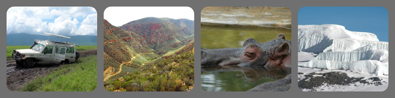
The cradle of civilization and one of the most complex areas on Earth, the continent of Africa is vast both geographically and culturally. A study of the geography and issues of Africa prepare students to better understand its richness and significance. This lesson is designed to give students a fundamental understanding of the physical and human geography of Africa, as well as the opportunity to explore issues facing it.

Guiding Question

  • How do human and physical characteristics of Africa influence its economic interdependence?

Learning Objectives
After completing the lessons in this unit, students will be able to:

  • Describe elements of the human and physical environment
  • Detect errors in reasoning and decide on an alternative
  • Construct, support, and defend a position

Product/Performance
Design a new highway route and support it with reasoned argument in the form of:

  • Small map of rejected route
  • Rationale for rejection of route
  • Chart of countries on rejected and proposed routes
  • List of countries and capitals on proposed highway
  • Magazine cover and article about the region large map showing physical and political places with proposed route
  • Memo to World Bank including design and support of new route

Introduction

A conference of African leaders has adopted as its top priority the building of a highway across the continent from Tunis, Tunisia to Cape Town, South Africa. The purpose of the highway is to foster political cooperation among the African nations and to promote economic development, trade, and tourism.

The highway will be financed by the World Bank, which, together with the African leaders, has recently rejected an initial proposal for the highway put forward by a competitor of your company and is now seeking alternate proposals.

You have been asked to submit to the World Bank a proposal for a better route for the highway. You will study a series of maps, data, atlases and other references to explain why the first route was turned down and create a new and improved route with reasoned support for it.

Enclosed is a request for proposal from the World Bank.

Proposal Package

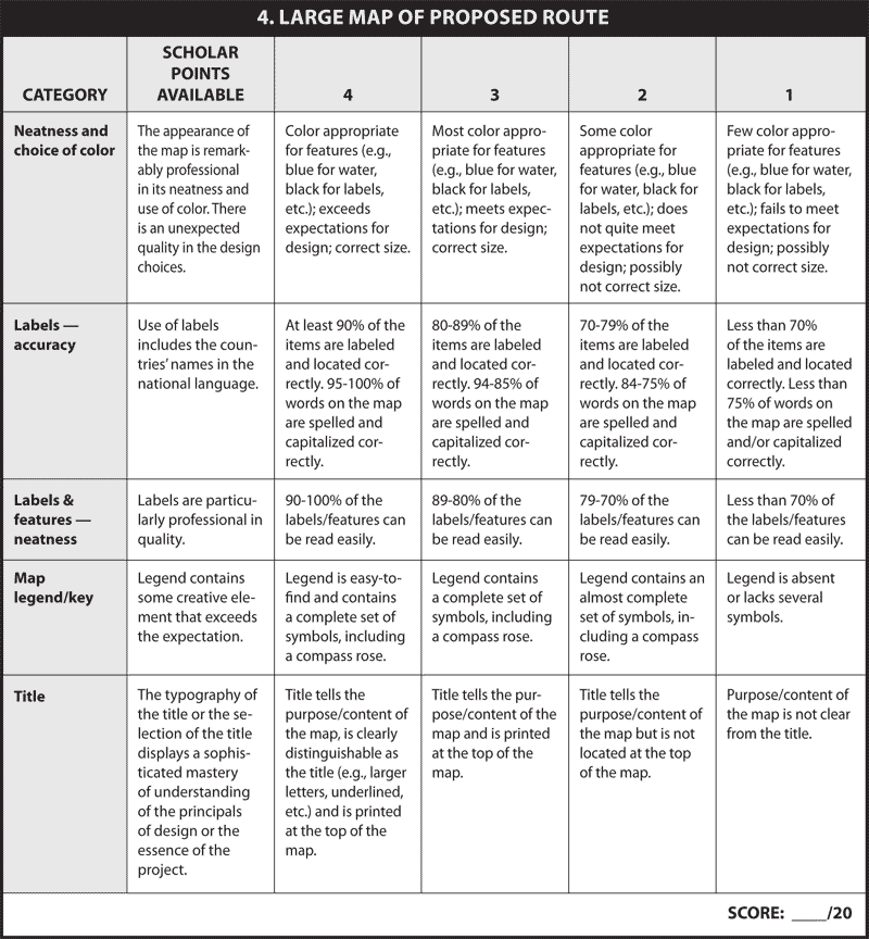
You will design a new highway route and support it with reasoned argument in the form of:

  • Small map of rejected route
  • Rationale for rejection of route
  • Chart of countries on REJECTED route
  • Chart of countries considered for PROPOSED route
  • List of countries and capitals on proposed highway (between 13 and 25)
  • Magazine cover and article about the region (economics and tourism)
  • Large map showing physical and political places with proposed route
  • Memo to World Bank including design and support of new route

Each of these components and the corresponding criteria are explained in the applicable section.

Panel of Africa-related images

Proposal Piece 1a. Analysis of Rejected Route

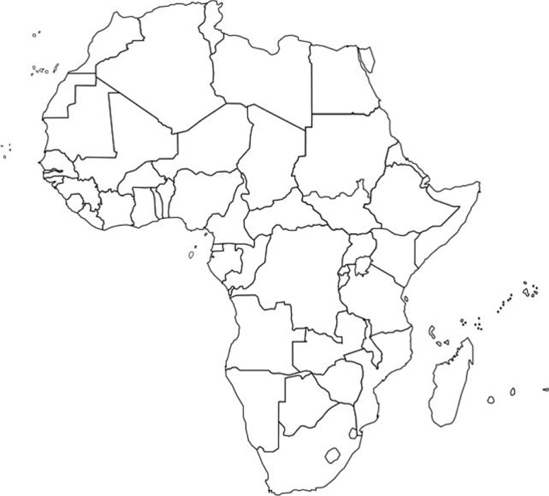
Below is an outline map of Africa and a list of cities connected by the initial proposal for the transcontinental highway.

Bulldozer

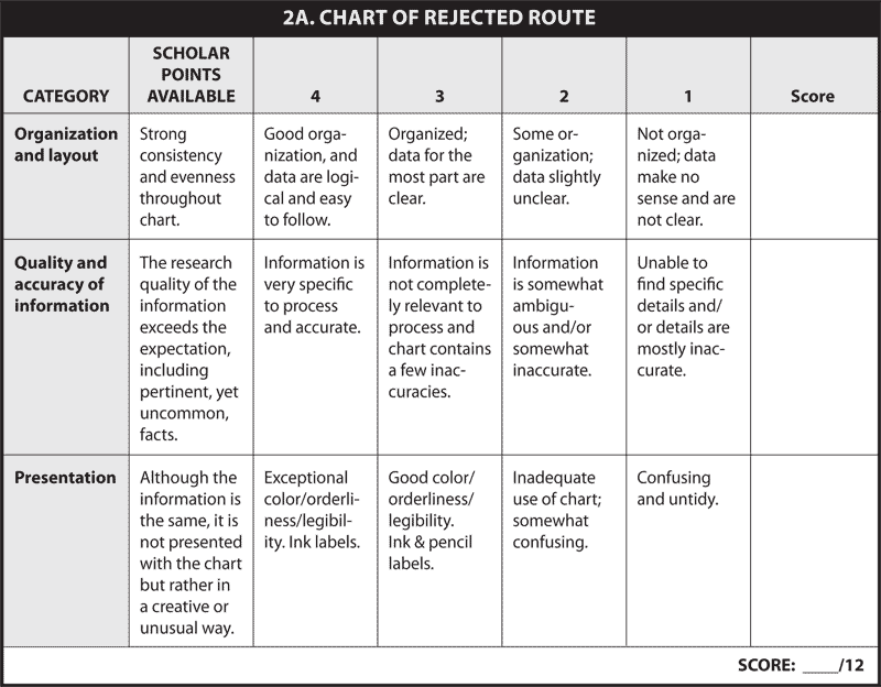
Draw the route of the initial proposal on the map and list reasons why you think it was rejected. To help formulate your reasons, consult atlases, lists of construction costs (below), and the purposes of the road. An online atlas is available at World Atlas. Additional sources of information include the CIA World Fact Book and InfoPlease.

Construction Costs: Terrain and climate influence the cost of road construction. Listed below are types of terrain ranked in order of expense for road construction, from most to least expensive:

  • mountains
  • rainforest/jungle
  • desert
  • bridge over major rivers
  • steppe
  • savanna

Roads are more expensive to build in humid, subtropical climates than in Mediterranean climates. You can find climate zone information at Blue Planet Biomes.

Draw the rejected route on the map using this order of cities:

1. Tunis, Tunisia 9. Nairobi, Kenya
2. Algiers, Algeria 10. Dar es Salaam, Tanzania
3. Niamey, Niger 11. Lilongwe, Malawi
4. Abuja, Nigeria 12. Lusaka, Zambia
5. Yaounde, Cameroon 13. Harare, Zimbabwe
6. Brazzaville, Congo 14. Johannesburg, South Africa
7. Kinshasa, Democratic Republic of the Congo 15. Port Elizabeth, South Africa
8. Kampala, Uganda 16. Cape Town, South Africa

Map of rejected route

Map of Africa


Proposal Piece 1b. Rationale for Route Rejection

Using the atlases and other rationale, state three reasons that the World Bank and African leaders might have rejected the proposed highway. Include specific data you obtained and note the sources. Keep in mind the purpose of the construction of the highway:

  • Encourage economic development and trade among countries
  • Promote tourism
  • Promote political and economic cooperation between countries
  • Stimulate economic development
  • Develop a transportation system

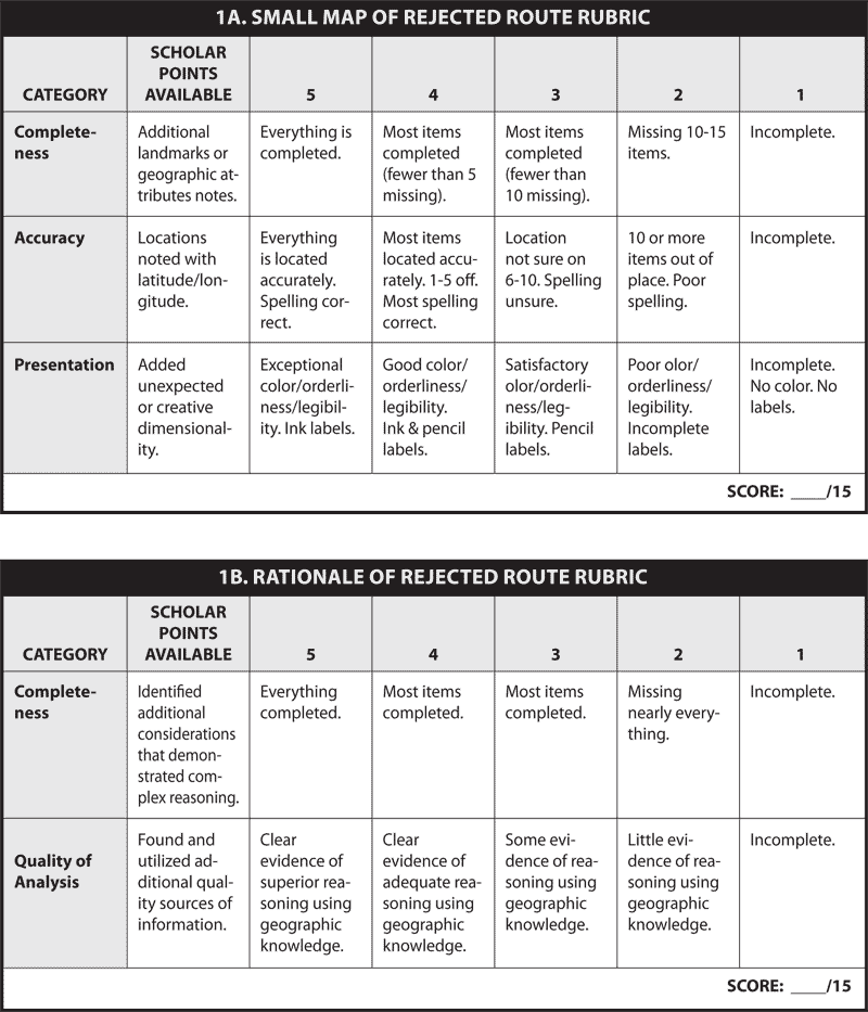
Determining the probable Reasons for rejection of the initial proposal:

  1. Physical Geographic Reasons:
  2. Human Geographic Reasons:
  3. Other Factors:

Rubric: 1a, 1b


Proposal Piece 2. Information about the Routes

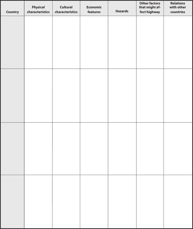
Now, you will complete analytical charts of the countries include in the rejected and proposed routes. Using the templates below, note the important elements in each category for the country listed.

Chart of Rejected Route

Chart of Rejected Route (cont.)


Proposal Piece 2b. Chart of Proposed Route

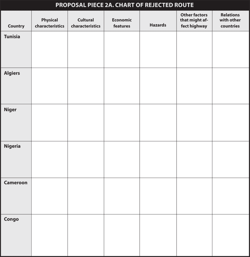
The chart below will form the basis of your choices for countries through which to plan your proposed route. Remember that you may have countries on this chart that you do not end up choosing. Print as many copies of the chart page as necessary for your analysis. You may have duplication of countries from the previous chart.

After you have completed the chart, use the following criteria to analyze the countries for inclusion in your proposal.

The route must:

  • Cover a major portion of the continent
  • Connect major population centers
  • Cross a minimum of 13 countries and a maximum of 25
  • Pass through at least one capital city on the Atlantic Ocean and one capital city on the Indian Ocean

Think about:

  • Topography (control construction costs)
  • Climate (try to avoid harsh areas)
  • Environment (build where it would cause the least damage)
  • Location of natural resources (What will you need to build and how will you get it there?)
  • Location of major/capital cities (ensure contact with highest number of people)
  • Tourist attractions (infusion of foreign capital, improve balance of trade)
  • Political considerations (War? Refugees?)
  • Health issues (tsetse fly, dengue fever, AIDS, Ebola — avoid where possible)

Panel of Africa-related images 2

Proposal Piece 2b. Chart of Proposed Route

Chart of Proposed Route


Proposal Piece 2c. List of Countries/Capitals Connected by Proposed Hightay in Order

Chart of Proposed Route

Proposed Route Rubric

Proposed Route Rubric (cont.)


Proposal Piece 3. Magazine — Issues in Africa

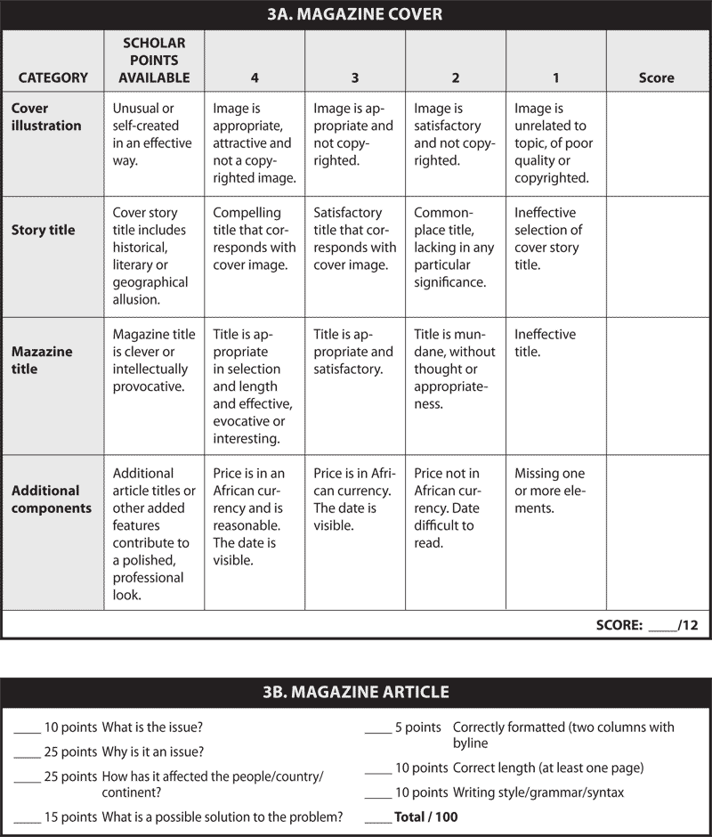
You will design a magazine cover and write an article about an issue in Africa that includes a possible solution.

Proposal Piece 3a. Magazine cover

You will use Big Huge Labs to create the cover.

  • Select an original title for the magazine.
  • Select a title for the cover story.
  • Select an image about the issue you selected. Be sure to use an image in Creative Commons. Do not use copyrighted material.
  • Include the price of the magazine (put the amount in an African currency).
  • Include the date of the magazine.
  • The cover should be neat, attractive and colorful.
  • You may wish to have titles of additional articles on the cover.


Proposal Piece 3b. Magazine Article

Select ONE of the following issues in Africa (there may be others — if you are interested in an issue you don't see here, you may choose another).


Lasting effects of apartheid Low life expectancy
Endangered animals (poaching) Refugees
Illiteracy Poverty
Civil war Starvation and famine
Disease (AIDS, malaria, etc.) Genocide
  • Discuss the issue in Africa that was selected for the cover story.
  • Be sure to include why it is an important issue and how it has affected the people, a country, or the continent.
  • Be sure to include solutions to help solve the issue.
  • The title of the article is the cover story (see step 3a above).
  • Write the article using the same format that you would find in a magazine. It will need to be at least one page with two columns. You may illustrate your article, but make sure you cite your source and make sure that you add the extra text to make up for it (pictures don't count toward the length of the article). Don't forget your byline (the author who wrote the article).

Magazine Rubric


Proposal Piece 4. Large Map of Proposed Route

Globe image

Considerations for your route:

The map should

  • Be at least ½ of a poster board
  • Be well-colored, neat, and attractive in appearance
  • Appropriately convey the route
  • Contain a legend
  • Be accurate and easy to interpret
  • Be labeled well (spelling counts)

The route must

  • Cover a major portion of the continent
  • Connect major population centers
  • Cross a minimum of 13 countries and a maximum of 25
  • Pass through at least one capital city on the Atlantic Ocean and one capital city on the Indian Ocean

Think about

  • Topography (control construction costs)
  • Climate (try to avoid harsh areas)
  • Environment (build where it would cause the least damage)
  • Location of natural resources (What will you need to build and how will you get it there?)
  • Location of major/capital cities (ensure contact with highest number of people)
  • Tourist attractions (infusion of foreign capital, improve balance of trade)
  • Political considerations (War? Refugees?)
  • Health issues (tsetse fly, dengue fever, AIDS, Ebola — avoid where possible)

Proposed Route Rubric (cont.)


Proposal Piece 5. Memo to World Bank

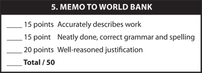
Memo: Final Proposal for Route across Africa

To: The World Bank
From: ________________________________
Subject: Alternate Proposal for Route across Africa

After considering the data and the rejected highway route, I have designed an alternate proposal, which is included here in map form, accompanied by supporting documentation. The proposed highway meets the following criteria:

  • Crosses a major portion of the continent.
  • Connects major population centers.
  • Crosses _____ countries.
  • Passes through the capital city of ________________________ on the Atlantic Ocean and the capital city of _________________________ on the Indian Ocean.
  • Is practical and crucial to the economic development of Africa.

I have emphasized the influence of the physical and human geographic features of the continent in designing our proposal.

Keeping in mind the purposes of the highway, I submit the four specific reasons this proposed route is superior to the rejected plan. I am including reasons concerning physical, cultural, and economic geography, and ________________________ (personal choice).

Include reasoning for the highway with these in regards:

  1. Physical
  2. Cultural
  3. Economic
  4. Personal Choice

Respectfully Submitted,
________________________________________

Cumulative rubric

Cumulative rubric


This series of lessons was designed to meet the needs of gifted children for extension beyond the standard curriculum with the greatest ease of use for the educator. The lessons may be given to the students for individual self-guided work, or they may be taught in a classroom or a home-school setting. Assessment strategies and rubrics are included at the end of each section. The rubrics often include a column for "scholar points," which are invitations for students to extend their efforts beyond that which is required, incorporating creativity or higher level technical skills.